Welcome to the Polar Vortex Blog!
We are excited to announce that NOAA Climate.gov, home of the highly popular ENSO Blog, is venturing into a colder, darker, and windier corner of the atmosphere with the new Polar Vortex Blog. We plan to explore various facets of the winds, climate, and chemistry within the fascinating region of the atmosphere known as the polar stratosphere, and explain how this region can sometimes drive big changes in our weather patterns!
While ENSO may be the seasoned celebrity in the seasonal forecasting world, in recent years the stratospheric polar vortex has become a rising star: constantly making headlines and being stalked by the paparazzi, but often misunderstood or misrepresented. We hope to clear up misconceptions, highlight new research, and discuss what the polar vortex is up to and how it may affect our winter’s weather. We expect there to be 1-2 posts per month between December and March, with the initial focus on the Northern Hemisphere polar vortex (yep, there’s one down south, too!).
So who’s on the team?
- Amy Butler is a research scientist at the NOAA Chemical Sciences Laboratory and an expert on the stratosphere and its influence on weather;
- Laura Ciasto is a meteorologist at the NOAA Climate Prediction Center. She leads the development of stratospheric and teleconnection forecast products, but is also a Week 3-4 forecaster (NOAA’s description for forecasts of weather conditions 3-4 weeks in the future);
- The Climate.gov graphics and data visualization team and managing editor, Rebecca Lindsey, with the NOAA Climate Program Office.
While we [Amy & Laura] are the lead editors of the blog, we hope to have guest contributors who can share their own perspectives and research on the polar vortex and related topics. And of course, this blog will not succeed without active engagement from you, our readers. We are happy to hear your constructive feedback and suggestions, and are excited to engage with you on this topic!
After reading this introduction, the first question you might have is likely: What is the polar vortex? And so, that’s where we’ll begin!!
What is the stratospheric polar vortex?
In recent years, most people have heard the phrase “the polar vortex”, which has made regular appearances in media headlines, often with an exciting, albeit sometimes ominous “Day after Tomorrow”, flavor:
- “Get ready: here comes the polar vortex”
- "Northeast U.S. latest to experience polar vortex temperatures”
- “Polar vortex invades central U.S.”
- “Polar vortex breaks record-low temps, snaps steel, empties cities”
But the “polar vortex” is not actually a synonym for “cold snap”; rather, it’s a well-known feature of Earth’s atmosphere that describes the high-altitude winds that blow around the pole every winter, miles above us in a region called the stratosphere.
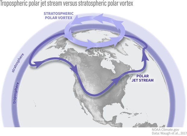
The polar vortex is in the polar stratosphere, above the layer of the atmosphere (the troposphere) where most weather, including the jet stream, occurs. NOAA Climate.gov graphic.
The stratospheric polar vortex forms in the winter hemisphere when the Earth’s pole is pointed away from the sun. The polar stratosphere enters darkness and becomes cold relative to the tropical stratosphere [footnote 1]. The temperature contrast makes for strong winds in the stratosphere that blow from west to east. This wintertime stratospheric wind is what we call the Arctic polar vortex [footnote 2].
An atmosphere dance party: who’s the wallflower, and who’s the extrovert?
If we were at a dance party, your first impression might be that the stratospheric polar vortex is the wallflower standing alone on the upstairs balcony, while the tropospheric jet stream is showing off on the dance floor with its flamboyant troughs, ridges, and cut-off lows. But as is so often true, first impressions are not always correct: while the polar vortex often doesn’t mind doing its own thing, it is not a passive watcher of the atmospheric dance down below. With some encouragement, polar vortex can actually become one of the most dynamic dancers there.
Making an impression
Why does the polar vortex matter to us, given it is so high and far away in the polar atmosphere? That’s one of the things we hope to explore in much more detail on this blog. But one of the main reasons is because the vortex does not always sit quietly by itself. Though it might (literally) need a little push from the troposphere to get its groove on, it can really break down with a move called a “sudden stratospheric warming”.
In this move, the polar vortex may wobble, swing far from its normal position over the pole, or stretch itself way out, sometimes even splitting in two (doing the “splits”? We can hear the groans from here…). And when this happens, the chances of cold weather across many populated regions can increase for many weeks afterwards.
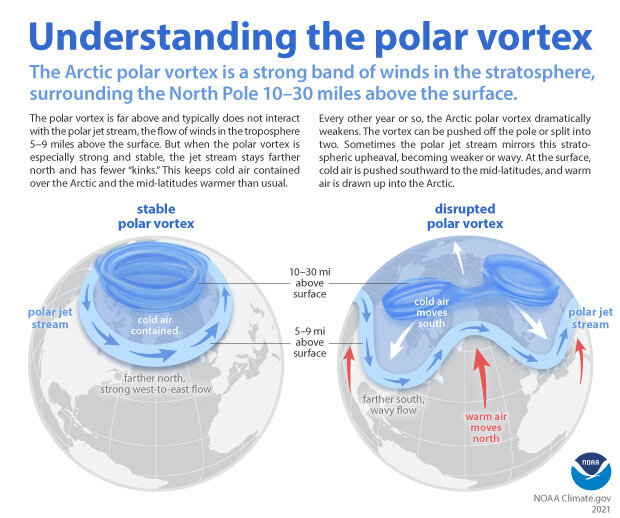
When the Arctic polar vortex is especially strong and stable (left globe), it encourages the polar jet stream, down in the troposphere, to shift northward. The coldest polar air stays in the Arctic. When the vortex weakens, shifts, or splits (right globe), the polar jet stream often becomes extremely wavy, allowing warm air to flood into the Arctic and polar air to sink down into the mid-latitudes. NOAA Climate.gov graphic, adapted from original by NOAA.gov.
Alternatively, sometimes the vortex does another extreme move where it becomes super fast and stable, encouraging the cold air at the surface to stay over the pole, which increases the chances of winter heat extremes in some regions. We will be getting into all the details of these events and their influence on our weather in future blog posts.
Polar vortex groupies
It’s hard to not be fascinated by the strong silent type that suddenly wows you with its awesome dance moves, particularly when those moves can cause extreme weather impacts, so scientists and forecasters have increasingly appreciated the need to monitor what the polar vortex is doing. We usually start by looking at the zonal (east-west) winds at 60N (the latitudes near Anchorage, AK or Oslo, Norway) at around 19 miles (30 kilometers) in altitude, where the air is so thin that the pressure is only 10 millibars (10 hectoPascals). By looking at a time series of these zonal winds we can get an idea of whether the polar vortex is really strong and stable, or weakening and ready to bust into its sudden stratospheric warming moves.
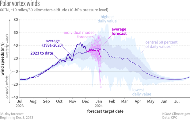
In early December 2023, NOAA's Global Ensemble Forecasting System (GEFS for short) began hinting that the winds of the Northern Hemisphere polar vortex might be about weaken. The spread of the individual forecasts is still pretty wide (thin pinkish-purple lines), but the average (heavier, bright purple line) predicts that winds will be weaker than average (royal blue line) in December. Climatology of highest and lowest daily values is from Climate Forecast System Reanalysis. NOAA Climate.gov graph, adapted from original by Laura Ciasto.
In addition to the strength of the vortex, we often want to know more about its shape. A great way to do this is by simply looking at a map of the thickness of the atmosphere. Throughout the winter, the polar vortex can shift, stretch, or just wobble from its usual spot over the pole, kind of like dancing in place. During strong events or sudden stratospheric warmings, these moves become much more distinct. Seeing the shape shows us which areas are poised to feel the biggest impacts of any unusual polar vortex behavior. There are other cool ways to see what the polar vortex is up to and whether it’s interested in tangoing with the troposphere but we’ll leave that for another post.
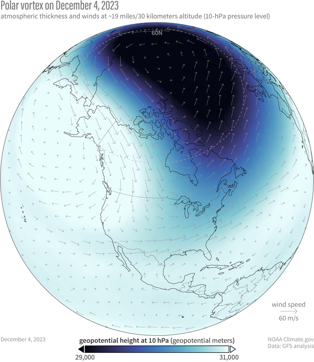
The polar vortex on December 4, 2023. Because the air within the polar vortex is generally much colder than the air outside of it, the polar vortex shows up on maps of atmospheric thickness ("geopotential height") as a region of low thickness. The 10-hectoPascal geopotential height is the altitude at which the pressure is 10 hectoPascals. NOAA Climate.gov image, based on Global Forecasting System (GFS) data from Laura Ciasto.
So what’s the polar vortex doing now? For the last few weeks it’s been embracing its wallflower persona as it sits over the polar region with stronger than average westerly winds. However, it does look like the stratosphere is at least thinking about joining the winter dance. If we look at the average of all the model forecasts from NOAA’s operational forecasting system (known as the Global Ensemble Forecasting System, or GEFS), it predicts that the zonal winds will weaken through the start of the new year.
The real question is whether the polar vortex just wants to dance in place (like it often does) or really show its steps. If we look at the individual forecasts that make up the average, some indicate that those westerlies at 60 degrees North* [Correction: see editor's note] will not only weaken but change direction to blow from east to west [footnote 3], which is how we define a sudden stratospheric warming. In addition, the leading forecast system for Europe (the ECMWF model, short for European Centre for Medium-range Weather Forecasting) shows an even higher likelihood that the vortex will be weaker than normal during December. These hints of a shift towards a weaker polar vortex means we will keep a close eye on whether the polar vortex wants to join an early winter party or sit this one out.
*Editor's note: Revised on April 26, 2024. This sentence originally said, "...indicate that those polar vortex westerlies...". It's been revised to prevent confusion between the polar vortex as the average atmospheric flow of the polar stratosphere and as a specific manifestation of that circulation on a given day. For more context, read We're going to stop saying "polar vortex reversal".
Further Reading
If you can’t wait for the next post to learn more about the polar vortex, our friends at the ENSO blog and at Climate.gov have posted several primers on the polar vortex and some of its most recent disruptions.
- Polar Vortex
- Understanding the Arctic Polar Vortex
- 2021 Sudden Stratospheric Warming
- 2023 Sudden Stratospheric Warming
Other good references on the polar vortex:
- The Stratospheric Polar Vortex and Sudden Stratospheric Warmings
- What Exactly is the Polar Vortex?
- What’s in a Name? On the Use and Significance of the Term “Polar Vortex”
Footnotes
- Now, you might be thinking, “But isn’t the stratosphere always colder at the poles than it is at the equator? No! In the summer, it’s actually warmer. We’ll cover this in a future post.
- Most of our descriptions in this post are talking about the Arctic polar vortex, but there is also an Antarctic polar vortex at 60S. It has some of the same features as its Arctic counterpart, but the Antarctic polar vortex is also unique, often dancing to the beat of a different song. We’ll delve into that more in future posts.
- When the winds blow from west to east, as is typically the case with the stratospheric polar vortex, this is said to be “westerly” flow, and is marked by zonal wind speeds that are positive in sign. When the winds blow from east to west, which is what happens when a sudden stratospheric warming occurs, the flow is instead called “easterly” and is denoted by zonal wind speeds that are negative in sign.
Comments
Media gone wild
As you alluded, the problem with today's sensationalist media is that they treat the polar vortex as a surface phenomenon and something new. Heck, I studied the polar region upper circulation in meteorology school in the 1970s. The "vortex" term sounds ominous to people as well, some likening it to a hurricane or tornado.
On a Monday morning last winter in the Denver, CO area, I heard a radio announcer highlight, "A polar vortex moved thru Colorado over the weekend!" Huh? It was simply a strong arctic surge covering much of the state.
The media jumps on these new buzzwords like polar vortex or atmospheric river as if we never had severe arctic cold waves or excessive rain flooding in past U.S. weather history. The more a NOAA blog such as this can help calm down the hysteria, the better.
Thanks for your comment! Yes…
Thanks for your comment! Yes we agree that the phrase "polar vortex" gets misused all the time. We get it, it's just more fun to say "the polar vortex is coming" than to say "it will be cold this weekend", but the issue comes when a term that has a specific meaning is used in multiple different ways- it becomes much harder to communicate what is really happening. We hope this blog can help to clarify what the term "polar vortex" really means, and how it's related to (but not the same as) cold air outbreaks and polar fronts.
PV Collapse
Omfg polar vortex is collapsing!!! Do we need to flee/scurry???
Nope, if the polar vortex…
Nope, if the polar vortex becomes disrupted, it's pretty normal- happens on average about every other year. However, knowing a few weeks ahead of time if a polar vortex disruption is likely has the potential to provide knowledge about increased weather risks to energy, transport, agriculture, and health sectors in upcoming months, which could help them adapt where they focus their resources.
USA Storm System
Is PV instability at fault for the massive storm we've just experienced throughout much of the Eastern USA? Thank you for this outstanding resource!
It's important to emphasize…
It's important to emphasize that, even when the polar vortex exhibits one of its wild moves, it's really difficult to tie the polar vortex to specific weather events. We can say that changes in the shape or strength of the polar vortex might make certain weather patterns more likely, but it's hard to go beyond more probabilistic statements to attribution statements because there is so much that can affect how specific storms unfold. Here it's not clear exactly which weather you are referring to (maybe the Dec 9 Tennessee tornado outbreaks?) but this sort of weather can be even trickier because many things go into creating atmospheric conditions for tornadoes to occur and the polar vortex has no direct influence on most, if any, of those conditions. Could polar vortex variations be related in a probabilistic sense to wintertime tornadic outbreaks? Maybe, but more research needs to be done to understand these connections.
Great blog and expectations for future posts
Great to see another polar vortex blog, good luck!. I got growing interest in this subject during my PhD on solar/geomagnetic impacts on decadal climate variablity and I am now following forecasts/other blogs/twitter on a daily basis. What always frustrate me is my lack of physical understanding on how the tropospheric wave pattern impact the polar vortex, e.g. wave breaking, wave interference etc. and under various stratospheric states. Likewise, the stratosphere doesn't always impact the troposphere/weather. Hope to see blog posts on this part during the winter season.
Yes, we will delve into…
Yes, we will delve into these topics a lot more over the next few months. Thanks for reading!
about the text
i think that this is not the topic for me but great job in format hope you have a good day not a hate comment sorry for the kinda hate
Thanks for stopping by! We…
Thanks for stopping by! We hope you give us another try in the future.
Recent spike in 10Hpa temperatures
https://www.cpc.ncep.noaa.gov/products/stratosphere/temperature/10mb906…
I look foreword to reading your blog
The polar stratospheric…
The polar stratospheric temperatures did warm up quite a bit over the last 10 days! This was not a major sudden stratospheric warming, though, because the zonal winds did not reverse direction. It was a more minor warming, which happen fairly frequently in the polar stratosphere and are generally not associated with significant changes in surface weather- though more research is needed. It's possible this little warm up could help set the stage for a major event down the road though!
Really Nice Blog on PV
More graphics if you can squeeze it into the budget please. I've been interested in weather and climate my whole life. Sometimes the acronyms get to be a bit dense, so drawings and pictures are helpful. I'm looking forward to seeing how well polar vortex predictions line up with weather forecasts over the months ahead. Thanks for cooking this up.
Waiting for the southern sibling
I am already a big fan of the ENSO blog, and I got so excited when I knew we will have a Polar Vortex blog!! I'll follow for sure!
As a Brazilian meteorologist, cannot wait to read things about the Southern Vortex. Hope it shows up here often :)
SH polar vortex
Yes, we hope to talk more about the Southern Hemisphere polar vortex eventually too!
polar vortex
how is it looking heading into january
Is there a corresponding 'vortex' over the South Pole?
Glad to see a centralized discussion on this topic here in the US. I have been following an European blog called 'Severe Weather Europe' which discusses the polar vortex too.
So to my question above - is there a corresponding 'vortex' over the South Pole?
If we are to examine the impacts of 'warming' and other human induced weather related changes isnt it necessary to examine impacts at both poles?
I came to this blog because of a 'shout out' about it from Dr. Swain at WeatherWest.
Regards
SH polar vortex
Yes, there is a polar vortex in the southern hemisphere, but since it's summer in the southern hemisphere right now, there is no polar vortex there at the moment- it typically will start to reform in February. The Southern Hemisphere polar vortex has many similarities to the Arctic vortex but also many important differences. At some point we hope to get into these details!
THE? polar vortex
The planet is dipolar, and those of us who inhabit the southern hemisphere are interested in the similarities and differences between our respective vortices. But thanks for this start.
Yes, we hope to talk more…
Yes, we hope to talk more about the Southern Hemisphere polar vortex eventually too! Currently the polar vortex in the southern hemisphere is not there because it's summertime, but at some point we hope to discuss what makes the Southern Hemisphere vortex similar to (and unique from) the Northern Hemisphere vortex.
Are Polar Vortices Unique to Planet Earth
Got news of your blog from spaceweather.com Jan 9, 2024
Which of our solar system planets have polar vortices apart from our own?
Polar vortices on other planets
No, they are not unique to Earth and we have observed them on several other planets/moons in the solar system. To read more, see here:
https://agupubs.onlinelibrary.wiley.com/doi/full/10.1029/2020RG000723
Arctic Warming and Polar Outbreaks
What is the latest in the research into whether arctic warming is causing a weakening in the vortex, and thus more frequent polar outbreaks? Last I was following this, it seemed like the theoretical mechanism was accepted, but empirically we weren’t seeing the expected increase in frequency. Can’t find an update anywhere in the lay media or public science sites. Thanks!
Thanks for this question. At…
Thanks for this question. At some point we will write a blog post to delve into the various research in detail. The short answer is that while there are some indications from computer model simulations that Arctic sea ice loss *by itself* can drive an equatorward shift of the jet stream and possibly a weaker polar vortex, in the real world and in model simulations with all the various aspects of climate change included, this response does not show up in any robust way. Likely there are other things going on that cancel this effect out. Moreover, we expect increased temperatures from a warming climate to at some point (if not already) to overwhelm any circulation/dynamically-driven cold air outbreaks. That doesn't mean that we can't still get record daily lows and very cold Arctic outbreaks, it just means that we will start to see fewer of them relative to daily record highs. And indeed, that is what has been happening (see for example Fig 2.4 here: https://nca2023.globalchange.gov/chapter/2/#key-message-2)
Polar Vortex
Thank you so much! I understand a little better why I get to freeze my butt off in Vermont sometimes. The rest of the time its not bad at all and downright gorgeous all the time!
Thanks for reading!
Thanks for reading!
Loved it!
Amazingly explained. Loved how you compared polar vortex to the shy wallflower. The mechanism is now etched in my mind. Would love to read more of this blog. Thank you!
Great!
So glad you found it helpful.
The Polar Vortex Reversal
Is there a data base for the dates of the polar vortex reversals since record keeping began I think it said 1979? I am curious if there was a similar one to this one in progress in 2017? I read on www.SpaceWeather.com site that the current one is the strongest since record keeping began?
Thank You.
I am a volunteer spotter with the US Weather Service in Portland Oregon.
So all this kind of activity really interests me.
Sudden Stratospheric Warming dates
A great resource for sudden stratospheric warming dates is: https://csl.noaa.gov/groups/csl8/sswcompendium/
Included is a table that list all dates back to the 1950s: https://csl.noaa.gov/groups/csl8/sswcompendium/majorevents.html
There was no major warming in 2017, but there was in February 2018.
The article is referring to the largest spike in ozone since 1979. In terms of the wind reversal itself, it's in the top 6.
Comments have been disabled on this article