United States El Niño Impacts
By this point, most of you have heard that it looks like El Niño is coming, and maybe you’re wondering why you should care. After all, why should it matter if the tropical Pacific Ocean becomes warmer than average? That’s thousands of miles away from the continental United States. Well, it turns out that El Niño often results in changes in the patterns of precipitation and temperature across many parts of the globe, including North America (Ropelewski and Halpert 1987, Halpert and Ropelewski 1992).
Many folks probably remember the heavy rainfall, flooding, and landslides that occurred in California in 1982/83 and again in 1997/98. As the region suffers through a devastating drought, it could be something of a relief if we knew for certain that El Niño would bring similar soaking rains. But those two events were the 2 strongest El Niños in the past 60 years, and we’ve seen many other El Niño years where California didn’t experience those types of devastating impacts. So assuming El Niño develops, what can we expect across the United States and when can we expect it?
By examining seasonal climate conditions in previous El Niño years, scientists have identified a set of typical impacts associated with the phenomenon (Figure 1). “Associated with” doesn’t mean that all of these impacts happen during every El Niño episode. However, they happen more often during El Niño than you’d expect by chance, and many of them have occurred during many El Niño events.
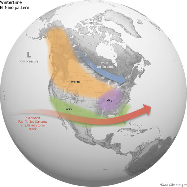
Average location of the Pacific and Polar Jet Streams and typical temperature and precipitation impacts during the winter over North America. Map by Fiona Martin for NOAA Climate.gov.
In general, El Niño-related temperature and precipitation impacts across the United States occur during the cold half of the year (October through March). The most reliable of these signals (the one that has been observed most frequently) is wetter-than-average conditions along the Gulf Coast from Texas to Florida during this 6-month period. This relationship has occurred during more than 80% of the El Niño events in the past 100 years.
In Southern California and U.S. Southwest, strength matters
Over California and the Southwest, the relationship between El Niño and above-average precipitation is weaker, and it depends significantly on the strength of the El Niño. The stronger the episode (i.e., the larger the sea surface temperature departures across the central equatorial Pacific are), the more reliable the signal in this region has been.
For instance, during the two strongest events in the past 60 years (1982/83 and 1997/98), much-above-median rainfall amounts fell across the entire state of California. Median or above-median precipitation was recorded over the entire state during strong episodes in both 1957/58 and 1972/73 (Figure 2). However, strong events in 1991/92 and 2009/10 only provided small surpluses in the southern part of the state, while precipitation during 1965/66 was generally average to below-average across the state.
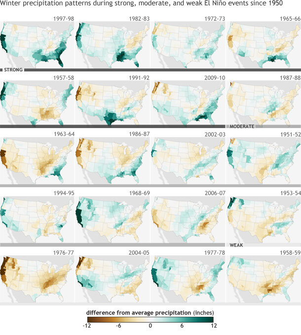
Figure 2. DIfference from average (1981-2010) winter precipitation (December-February) in each U.S. climate division during strong (dark gray bar), moderate (medium gray), and weak (light gray) El Niño events since 1950. Years are ranked based on the maximum seasonal ONI index value observed. During strong El Niño events, the Gulf Coast and Southeast are consistently wetter than average. Maps by NOAA Climate.gov, based on NCDC climate division data provided by the Physical Sciences Division at NOAA ESRL.
For weak and moderate strength episodes (Figure 2), the relationship is even weaker, with approximately one-third of the events featuring above-average precipitation, one-third near-average precipitation, and one-third below-average precipitation.
Elsewhere over the United States, El Niño impacts are associated with drier conditions in the Ohio Valley, and there is a less-reliable dry signal in the Pacific Northwest and the northern Rockies. Hawaii also often experiences lower-than-average rainfall totals from the late fall through early spring period.
The climate impacts linked to El Niño help forecasters make skillful seasonal outlooks. While not guaranteed, the changes in temperature and precipitation across the United States are fairly reliable and often provide enough lead time for emergency managers, businesses, government officials, and the public to properly prepare and make smart decisions to save lives and protect livelihoods.
Definitions
Weak El Niño: Episode when the peak Oceanic Niño Index (ONI) is greater than or equal to 0.5°C and less than or equal to 0.9°C.
Moderate El Niño: Episode when the peak Oceanic Niño Index (ONI) is greater than or equal to 1.0°C and less than or equal to 1.4°C.
Strong El Niño: Episode when the peak Oceanic Niño Index (ONI) is greater than or equal to 1.5°C.
References
Halpert, M.S. and C.F. Ropelewski, 1992: Surface Temperature Patterns Associated with the Southern Oscillation, J. Clim., 5, 577-593.
Ropelewski, C.F. and M.S. Halpert, 1987: Global and Regional Scale Precipitation Patterns Associated with the El Nino/Southern Oscillation, Mon. Wea. Rev., 115, 1606-1626
--- Emily Becker, lead reviewer
Comments
RE: New England.
As mentioned earlier, the relationship between El Nino and weather/climate in New England is not very strong. The Climate Prediction Center does have a webpage that shows U. S. seasonal composites of temperature, precipitation, and snowfall that may be of interest. However, there is no level of significance associated with these composites, other than the frequency with which these departures have occurred in the past. These figures do show a tendency for snowier El Nino winters New England.
http://www.cpc.ncep.noaa.gov/products/precip/CWlink/ENSO/composites/
El Nino
RE: El Nino
El Nino tends to favor a drier than average winter in most of Ohio, and the CPC seasonal outlooks for DJF and especially JFM reflect that.
El Nino's varies
RE: El Nino's varies
Since El Nino is not the factor that affects the climate, none of the relationships discussed here occur every time. What El Nino does enable us to do is to issue outlooks that favor either wetter or drier, warmer or cooler weather, than average over certain regions of the country during certain seasons. These outlooks also say nothing about the specific variabiltiy of the weather during the season, so you're correct in that we're not able to say anything about a particular storm. That would be a weather forecast and at this time, meteorologists are able to skillfully (not perfectly) forecast the weather out to to about 7 days.
This developing El Nino has
El Nino
RE: El Nino
The updated climate prediction center outlooks do favor above average temperatures in much of the Pacific NW during July - September:
http://www.cpc.ncep.noaa.gov/products/predictions/long_range/seasonal.p…
tornado outbreak from el nino in central oklahoma
RE: tornado outbreak from el nino in central oklahoma
Links between severe weather and El Nino are not well defined. There does appear to be a tendency for El Nino to be associated with enhanced severe weather during the winter months in the Southeast and Florida.
Worried In Southern Cali....
Figure 2 classification scheme
Warming Oceans
weather in general,
Affects of El Nino On Northern Rockies
RE: Affects of El Nino On Northern Rockies
El Nino can lead to warmer-than-average winters in the region of the Northern Rockies (see Fig. 1). There has been a lot of variation during El Nino in the past as far as precipitation goes (Fig. 2), but the CPC's winter outlook calls for less precipitation than average.
how will El Nino affect Iowa this summer and winter?
ctlweather
Post-fire flooding
Visit California
florida affect
Puerto Rico
El Niño and south texas
El Nino
Central Texas
Hoping for snow :)
El Nino
el nino
RE: el nino
If there is a weak El Nino in 2014/15, as predicted, there is no particular predictable effect on precipitation in the the piedmont portion of North Carolina during winter. To the west there would be a tilt of the odds toward below normal precipitation, while to the east (and south) there would be slightly enhanced probability for above normal. As for temperature, there would likewise be no strong expected preference for anomalies in central North Carolina, although not far to the south there would be an expectation of slightly below normal temperature (and slightly above normal precipitation). So we don't expect a repetition of the severe winter of one year ago.
ENSO effect
RE: ENSO effect
Often the Atlantic will warm(not cool) to some degree after the Pacific has warmed, in response to changes in the circulation throughout the Tropics.
El Nino Stuff
North Texas Dry Lakes
We have had the coldest
El Nino Impact Across TX May 2015
RE: El Nino Impact Across TX May 2015
The usual effect of El Nino on Texas rainfall is to increase the chance of above average rainfall during winter and spring (up until about May), and then have little or no effect through summer and much of the fall, and then to increase it again as winter approaches. So your above-average rainfall could be due to the weak El Nino conditions we have had over the last few months. But since El Nino's influence on Texas rainfall is minimal after about May, I would not expect a continuation of your high rainfall going into June. If it does continue, it would be due to factors other than the El Nino. Then, if this El Nino is still going on next November or so (and current model forecasts indicate that it will), you may see a wet winter in 2015-16.
El Nino and the persistent high pressure systems in the West/&SW
Yes, the El Nino does change
Yes, the El Nino does change the persistent high pressure observed in the southwest over the last several years. As illustrated in the last figure of Emily's blog post a week or two ago, http://www.climate.gov/news-features/blogs/enso/june-el-ni%C3%B1o-updat…, during El Nino the Pacific jet stream usually is extended so as to encroach on the southwestern US, bringing its storm track with it. This means that even if there is still a tendency toward a high pressure ridge over the western US, there could be repeated interruptions as low pressure systems undercut the ridge on its southern side over southern California and Arizona. So there is hope for some relief from the drought, especially south of 35 N latitude, and if it turns out to be a very strong event, the better rainfall (especially in late winter, Jan-Mar) could benefit central or even northern California as well.
El Nino flooded OK in Spring. ??This Winter?
Updating the Categories of El Niño
RE: Updating the Categories of El Niño
We have not updated the image above showing the various categories of El Nino. While the transition to using ERSSTv4 did change designations of strength for some events, overall the changes were not drastic when it comes to the image in this blog post.
To answer your last question, no we have not added a "very strong" category. The categories remain three monthly averaged ONI values as follows:
> 0.5C - Weak
>1.0C - Moderate
>1.5C - Strong
Climate Change
Lk Supeior snow belt
Winter
RE: Winter
Yes, western Kentucky is part of the "Ohio Valley" region that typically gets somewhat less than average winter precipitation during El Nino, while getting near-normal to just slightly above-normal temperature. You're likely to get some relief from a harsh winer this year.
El Nino
El Nino
RE: El Nino
You can find CPC's January-March forecast here. There doesn't appear to be a great signal for East Tennessee.
SUP
south central
Comments have been disabled on this article