Time and Tides
Looking Ahead to Protect Puget Sound
On a recent tour of the Port of Everett, just north of Seattle, Washington, Marla Steinhoff pauses to share her perspective on climate change. She points to a row of barrels filled with industrial solvent, neatly stacked and shielded from the weather by tarps.
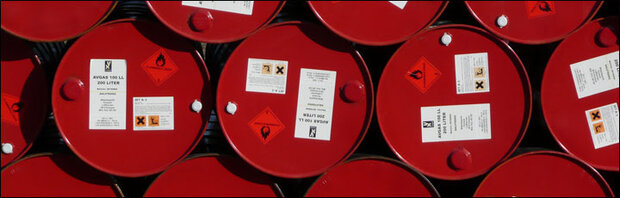
Several sites around Puget Sound store oil and other industrial fluids in large-capacity barrels. Photo courtesy of ezioman.
"These materials are being taken care of," she says, "but I worry a bit that Puget Sound won't be totally safe in the long run. Some locations where potentially dangerous materials are stored or spilled will be threatened by rising seas in the next several decades."
For most of us, only time and tides will tell. The effects of our planet's slowly-but-surely increasing sea level are hard to imagine, and even harder to plan for. But for Steinhoff, the call to be aware of the threats is obvious and immediate. "While most city planning efforts focus on the next 10 to 25 years, we're seeing the need to think further ahead, say 50 to 75 years out," she says.

Marla Steinhoff, of NOAA’s Office of Response and Restoration. Photo courtesy of NOAA.
As an environmental scientist with NOAA's Office of Response and Restoration in Seattle, Steinhoff is accustomed to taking that longer look at things. The "ah-ha" moment that increased the length of her view into the future came while she was enjoying the view of Puget Sound from the deck of a beachfront home. "Even though I was trying to relax, I kept having this mental image of the same deck, 100 years into the future, totally swamped by sea water," she said. As she thought further, she recognized that losing the deck would be a small issue compared to the environmental damage that could result from flooding of contaminated sites and industrial storage locations around the Sound.
For the past year, Steinhoff has engaged in work that could help people identify and avoid some of the damage that could accompany sea level rise in the Pacific Northwest. She has devoted her energies to developing the Climate Assessment and Proactive Response Initiative, also known as CAPRI.
Puget Sound, Then and Now
The arm of the Pacific Ocean that extends into the state of Washington, known as Puget Sound, is the largest and perhaps the most biologically productive estuary on the West Coast. Its earliest settlers, the First People of the Pacific Northwest, were extremely reliant on the Sound, building villages on its shores, where food was plentiful. Their preferred mode of transportation, the dugout canoe, could be loaded and launched easily, for fishing trips and journeys to other village sites.
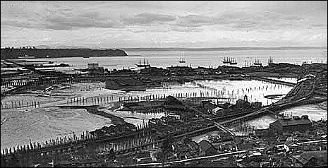
By 1900, structures along the waterfront in Seattle had begun displacing large areas of natural habitat along the shores of Puget Sound. Photo by Anders B. Wilse, courtesy of Museum of History & Industry.
In the 1800s, European settlements replaced Native American villages, initiating a new relationship with the Sound. Although the region was settled more recently than San Francisco Bay or Chesapeake Bay, Puget Sound shares many of the characteristics of these older bays-notably that development originated along the shoreline and continues to shape the identity of the region to this day.
"The fast, largely unregulated pace of growth throughout Puget Sound brought some less-than-desirable changes as well," says Steinhoff. "All those new sawmills, shipyards, smelters, and homes essentially wiped out some of the Sound's waterfront habitats and degraded many others."
Today, Puget Sound is home to an expansive urban metropolis, major military bases, and areas that support economically valuable wildlife and recreational activities such as hiking, kayaking, and birdwatching.
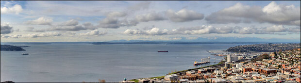
Puget Sound as viewed from the Space Needle in Seattle, Washington. Photo courtesy of Buphoff.
Steinhoff and her coworkers at NOAA's Office of Response and Restoration in Seattle, Washington, collaborate with others to protect and restore coastal and marine resources threatened or injured by releases of hazardous substances. One part of the group's work is to respond to oil spills-since April of 2010, the office has been very involved with efforts to assess damage resulting from the Deepwater Horizon oil spill in the Gulf of Mexico. During cleanups of large-scale waste sites led by the U.S. Environmental Protection Agency or state agencies, the group helps people assess the risks to fish, marine mammals, and other ecological resources. As its name indicates, the Office of Response and Restoration also assists in developing cleanup options and restoring habitat after damage has been done.
Federal and state agencies have already made considerable progress in addressing large-scale cleanups in Puget Sound, but much remains to be done. Recent projections on the effects of climate change, notably sea level rise, have added a sense of urgency to this mission.
"Scientists predict that the effects of global warming will pose serious threats to both land and water across Puget Sound," says Steinhoff. "Sea level rise-projected to be anywhere from one foot to five feet in the next century-will change the shoreline significantly. In Seattle, for example, much of the land lies just a bit more than three feet above the current high water mark. As such, there could be significant flooding in several places -including the land around Safeco and Qwest fields, where the Mariners and Seahawks play."
Even conservative estimates for sea level rise could put many of the Sound's contaminated sites, chemical storage tanks, oil storage facilities, and gas and oil pipelines in grave danger of being swallowed by seawater.
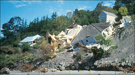
Heavy rains can saturate soils, leading to landslides such as this one that occurred in Seattle in 1987. Photo courtesy of NOAA.
"And rising sea levels aren't the only things that climate change will bring," offers Steinhoff. "Projections of warmer winters suggest that we'll receive less snow and more rain, so we can expect to see some rivers overflowing their banks. Flooding that previously occurred once every 100 years could become a once-in-10-year event. As soils become saturated from heavy rains, mudslides will also become more frequent. We'll also need to deal with increased coastal erosion and more instances of seawater seeping into freshwater aquifers. We could be in for a real mess, with the impacts of climate change jeopardizing homes, businesses, public parks, and wildlife habitats throughout the Sound."
Creating a Visionary Tool
To better understand what could happen to sites and materials stored around the Sound and to help decision-makers identify a range of options for dealing with future changes, Steinhoff and other members of Office of Response and Restoration mounted an effort to build a computer-based tool for visualizing future changes. Building on their vision to show people what resources were at risk, they began the task of compiling and preparing an extensive suite of data and code. The team named the tool the Climate Assessment and Proactive Response Initiative, or CAPRI.
To incorporate realistic views of the future into the tool, the development team needed to build on a foundation of valid climate forecast data. CAPRI's developers could obtain global-scale data from Washington state agencies and the Intergovernmental Panel on Climate Change (IPCC), but they needed more detail than these projections offered. The team sought assistance from the University of Washington's Climate Impacts Group, researchers who have expertise in downscaling global-scale climate models to get a more detailed picture of how conditions might change across a region. The two groups worked together to come up with a way for CAPRI to simulate future conditions specific to the Pacific Northwest. "They brought regional-scale detail to what was formerly a broad-brush picture painted by the IPCC," says Steinhoff. "These data allow us to distinguish between changes projected for different areas across the region."
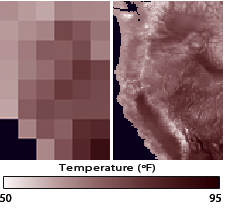
These two images show future projections of temperature for the western United States at different resolutions (levels of detail). The left image shows a very low level of detail. On the right, the output from a statistically downscaled model shows higher resolution.
CAPRI's development team also approached the National Wildlife Federation to seek their expertise. This group had developed sophisticated computer code that could simulate the major processes that change shorelines and wetland habitats as sea levels rise. Through a process of converting and massaging the code, the groups found a way to incorporate the function into CAPRI. The collaboration resulted in the ability for CAPRI to generate dynamic representations of changes to the coast over time.
Next, the Climate Impacts Group provided additional data that would make CAPRI more comprehensive. The group contributed valuable data on coastal habitats and marine life, including salmon, seabirds, and other vulnerable species.
To represent the risks to resources through out the Sound, NOAA staff prepared data that describe locations and characteristics of state- and EPA-led cleanups, oil storage facilities, and other sites that could become sources of land or water pollution.
"We also identified and prepared data on commercial and recreational fishing, beach access, and public parks," Steinhoff explains. "We wanted to be able to pinpoint the broad array of important places that are close to potential sources of contamination."
Putting CAPRI to Work
With the range of data and code prepared and plugged in, the tool is ready to reveal the relationships among climate change, potential contaminant releases, and natural and human resources. Based on the range of threats at various locations, CAPRI can calculate a combined vulnerability index for resources throughout the Sound.
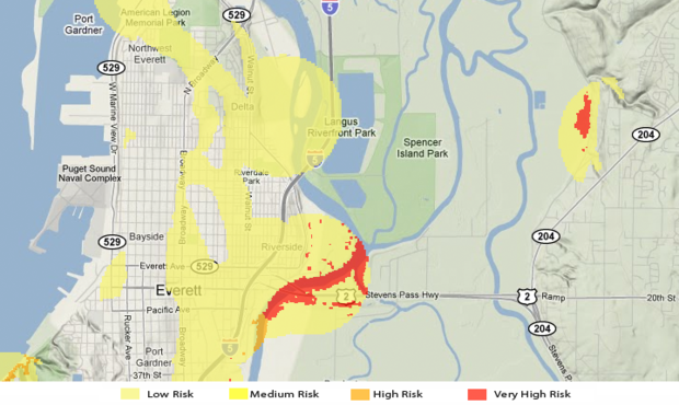
This image shows CAPRI’s Facility Index for the year 2100 with a projected sea level rise of around 5 feet (1.5 meters). Risk levels indicated by this index account for the degree of toxicity of contaminants at each facility in the region as well as the likelihood of their release.
To take a look at possible futures, users enter requests in a Web-based mapping tool, which accesses the regularly updated data and code of CAPRI. The mapping tool generates color-coded maps that indicate the vulnerability of resources at 25-year intervals in the future, under two climate-change scenarios. Thus, decision makers can check the projected status of resources in 2025, 2050, 2075, and 2100 for two different amounts of sea level rise.
Coastal and resource managers analyze patterns on the color-coded maps to evaluate the array of possible futures. The maps represent the complex relationships among threats and resources over time and space all in one place, enabling managers to decide when and where steps might be taken to deflect threats of inundation and contamination.
Recalling the barrels of solvent stored at the Port of Everett, Steinhoff points out, "Results from CAPRI can show Everett's port commissioners when those barrels might be affected by flooding. The tool can also help people identify locations for storage where the materials could be considered safe through 2100."
For planners managing the largest marina on the West Coast, CAPRI could also help identify effective measures for protecting the Port of Everett's docks, piers, and pilings from a range of threats. CAPRI can also show what might happen to nearby coastal habitats at the mouth of the Snohomish River if waste site cleanups in the area are not adequately addressed.
Projections from CAPRI are not only helpful for safeguarding the so-called ‘built' environment, Steinhoff points out. They may also be valuable in guiding efforts to restore fish and wildlife habitats.
NOAA’s Office of Recovery and Restoration has been involved in efforts to enhance salmon habitat in the Nisqually Wildlife Refuge, located in the southern reaches of Puget Sound.
For example, in 2009, federal planners and members of the Nisqually Tribe embarked on what has become the region's largest coastal wetland restoration project. After months of preparation at the Nisqually National Wildlife Refuge, a historic system of dikes was removed, allowing seawater to once again flow across 762 acres of prime wetland habitat. Project planners are hopeful that this action will give endangered Puget Sound salmon a way to reach much-needed spawning habitats, and also offer a safe environment for the hatchlings to feed and grow before heading out to sea.
"It's a fabulous project, but we don't know for certain how the impacts of climate change will affect the restoration effort," says Steinhoff. "Even CAPRI's most moderate climate-change scenario indicates that shoreline along the refuge could be re-shaped over the next 50 to 100 years, which could reduce the area of regained habitat. After seeing CAPRI's results, project planners might choose to pursue efforts to enhance additional shallow-water habitats within the refuge, to maintain longer-term benefits."
Applying CAPRI in Other Places
What might the capabilities of CAPRI reveal in other places? Steinhoff believes that insights and experience gained from the Puget Sound model might also help people manage potentially hazardous materials in Alaska, for instance. Over the past five decades, warming in that state has occurred at an average of more than twice the rate of any other part of the country. In addition to sea level rise, thawing of permafrost-the permanently frozen layer of soil that underlies much of the state-increases the risk of contamination events from ruptured pipelines that carry gas and oil. Steinhoff anticipates that the opportunity to use CAPRI to visualize the unique risks to resources across their state could help Alaskans set priorities for addressing threats related to climate change.
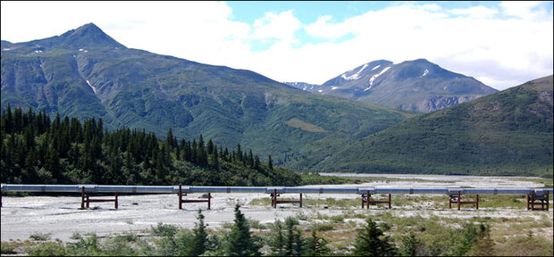
The Trans-Alaska Pipeline carries oil from the North Slope of Alaska to the shipping port in Valdez, Alaska. Photo courtesy of Matthew Verso.
Steinhoff also sees potential for CAPRI to help identify vulnerable resources along the Gulf Coast. Threats posed by the twin troubles of sea level rise and subsiding land in that part of the country are compounded by the potential for damage from hurricanes and storm surges. Steinhoff notes, "In general, coastal managers along the Gulf are aware of the threats they face. The increased awareness of resource vulnerability that comes with using a tool like CAPRI could help them choose proactive solutions to protect resources before continuing changes reduce the practicality of some options."
The potential of CAPRI is not lost on Joanna Ekrem, a policy analyst with the Washington Department of Ecology in Olympia. "Right now, several state agencies are crafting an Integrated Climate Change Response Strategy for submission to the Washington Legislature in December 2011," Ekrem says. "The CAPRI tool will provide us with a picture of the contamination levels that could accompany sea level rise. Having a better sense of the vulnerability of our coastal areas will help us protect sensitive ecosystems and preserve the shorelines of the state."
Though it may eventually be useful in a variety of locations, CAPRI is currently only available to coastal managers in Puget Sound. As the model for representing physical processes becomes more robust and the output is refined, the Office of Recovery and Restoration plans to introduce the tool to partners across the nation. If the community of coastal managers judges that CAPRI's projections and visualizations have sufficient value to assist them in their planning, the tool may be released formally, for implementation in new locations, and for use by the public.
Steinhoff recognizes that the fundamental value of vulnerability maps from CAPRI is their ability to show people exactly what is at risk and when that risk will increase. "Ultimately," she says, "time and tides will continue marching on. It will be up to coastal and resource managers to use what they learn from CAPRI to decide which resources should be protected and how."
David Gordon is the science writer for Washington Sea Grant. -
For further information:
The Climate Assessment and Proactive Response Initiative (CAPRI) Project homepage provides an overview of the project's analytical framework, example output from CAPRI for the Snohomish Estuary, and contact information for project personnel.
The Nisqually Delta Restoration site offers maps, photographs, and references related to the ongoing effort to assist in recovery of Puget Sound salmon and wildlife populations. The site is an unofficial informational outlet for groups working within the Nisqually Delta Restoration partnership.