A Hurricane in New England?
An Unannounced Visitor
New England has weathered its share of battering storms, and even an occasional tornado. With a few notable exceptions, however, most hurricanes that swirl northward along the East Coast veer out into the Atlantic without making landfall. Not so in 1938. The "Great New England Hurricane of 1938," also known as "The Long Island Express" or simply "The Big One," blindsided New Englanders that year, striking without warning in the afternoon of September 21.
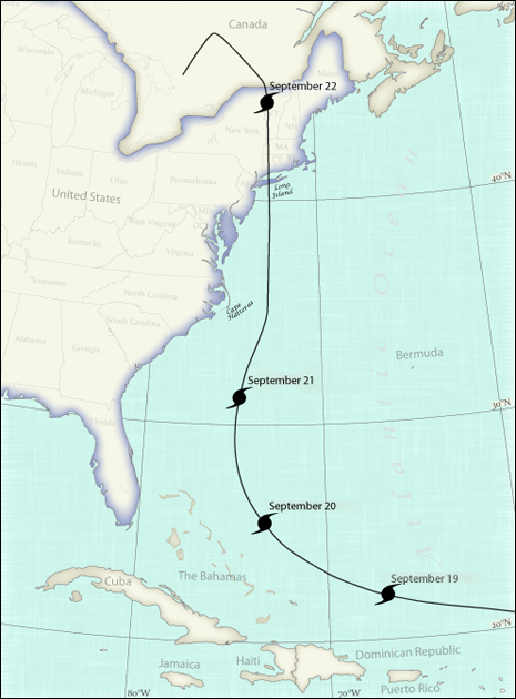
The Great New England Hurricane of 1938 started as a tropical cyclone off of Cape Verde, Africa, on September 10. After threatening Florida on September 20, it moved north, and most forecasters believed it would head northeast to spin itself out in the North Atlantic Ocean. Instead, the storm accelerated northward, reaching forward speeds of up to 50 miles (80 kilometers) per hour, on a beeline for the southern shore of New England. Map courtesy of Hunter Allen.
Late in the day on September 19, 1938, weather forecasters who had alerted Floridians of the possibility of a hurricane landfall saw that the storm had turned north. As the storm seemed to be heading out to sea, most of them breathed a sigh of relief and went home. Forecasts issued for the eastern seaboard that day contained high wind and gale advisories, but made no mention of a hurricane. Most of the ships that might have reported the storm's location had retreated to shore, waiting for the hurricane to spin itself out in the open waters of the Atlantic Ocean. Essentially unwatched, the hurricane abruptly tripled its northward speed, and traveled the 425 miles (700 km) from Cape Hatteras to Long Island in less than 8 hours.
When the storm plowed across Long Island and slammed into Connecticut, it was a Category 3 hurricane. The storm's rapid northward motion amplified the wind speeds on the east side of the storm, and buildings disintegrated under the force of wind-driven waves and rain. In an example of spectacularly bad timing, landfall occurred at the same time as high tide, maximizing the height of the deadly surge of seawater that was pushed ashore by the storm.
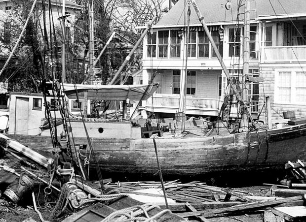
In the New England Hurricane of 1938, fishing boats and yachts were carried ashore by waves and wind. Here, homeowners found a large boat and industrial debris deposited in their yard. Photo by A. Morgan Stewart,The Day, courtesy of Peg Van Patten.
Beaches in Connecticut and Rhode Island were stripped clean of the summer cottages that had crowded their shores, and fishing boats were tossed about like toys, some settling as far as a mile inland. One startling arrangement of debris was a boat that had crashed right into a funeral parlor. As is common with strong hurricanes, many people died by drowning as the storm surge flooded their homes, schools, and businesses.
After battering the coast, the hurricane moved north, right into the heart of New England. When it was over, 57,000 homes from the Bahamas to Quebec were damaged or destroyed and around 600 people were dead (estimates vary). Total property damage from "The Big One" in New England was estimated at over $300 million in 1938-equivalent to almost $5 billion in 2010 dollars. Even when compared with the devastating Category 4 and 5 hurricanes that made landfall in the United States in 2004 and 2005, the Great Hurricane of 1938 still ranks as one of the most costly and deadly hurricanes in United States history.
What if another major hurricane were to hit New England this year? Would residents fare any better than they did in 1938?
A Life-shaping Event
My dad was a 29-year old freelance newspaper reporter then, writing mostly for The Day newspaper in New London, Connecticut. He recalled that the morning of September 21 had been a perfect beach day. As the storm approached and its severity became obvious, Dad fought his way to the school to retrieve my older brother, Russ, and brought him home. Russ recalls crouching behind an armchair, covered by his mother's body. When Dad shouted, "Here it comes!!" Russ remembers hearing an unearthly roaring sound, like a train thundering by at top speed.

Peg Van Patten, of Connecticut Sea Grant.
Russ was one of the lucky ones. Many children died in the storm, drowned where they huddled in a library, or tossed about by the violent waves that crashed ashore. In Rhode Island, a school bus, including children and driver, was washed out to sea and lost. My grandparents, who had a coastal farm on Barn Island, had gathered refugees in their home. As the group fled 12-foot waves to higher ground, they spotted a naked corpse in the yard.
Fishermen in Stonington, Connecticut, carry a wicker basket containing human remains found at the waterfront. The hurricane totally destroyed about 2,600 fishing vessels and damaged about 3,400 more. Immediately after the storm, only three commercial fishing vessels remained useable in Southeastern Connecticut and Rhode Island. Photo by A. Morgan Stewart, The Day, courtesy of Peg Van Patten.
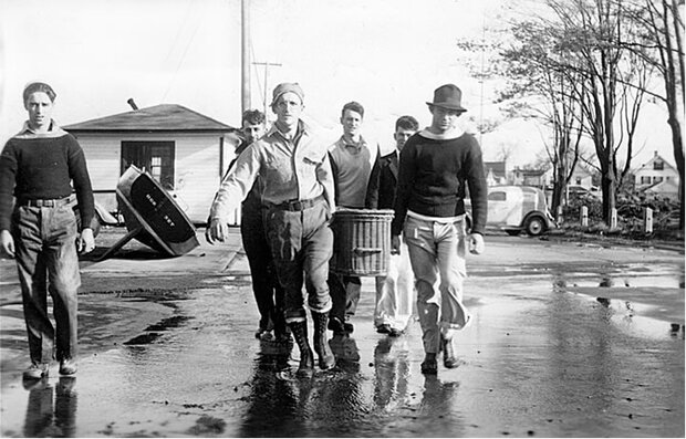
Fishermen in Stonington, Connecticut, carry a wicker basket containing human remains found at the waterfront following the New England Hurricane of 1938. The hurricane totally destroyed about 2,600 fishing vessels and damaged about 3,400 more. Immediately after the storm, only three commercial fishing vessels remained useable in Southeastern Connecticut and Rhode Island. Photo by A. Morgan Stewart,The Day, courtesy of Peg Van Patten.
My dad, who had a considerable vocabulary, was so shocked at the devastation he saw that evening and the following day that he could hardly write. Instead, he relied on his camera, and took many photos to tell the story. Much of the city of New London had burned after sparks from downed power lines caused businesses and a coal company to catch fire. The Day lost power, but sent its reporters and photographers out into what it later called "the Stygian darkness" and through smoke like "the devil's furnace," at risk to their lives. The combined effects of the hurricane-winds, floods, and fire-caused $4 million in property damage in New London alone.
The Bostonian train encountered fishing boats and a house that had been deposited on its tracks. Lumber from the wreckage of buildings was everywhere. Photo by A. Morgan Stewart, The Day, courtesy of Peg Van Patten.
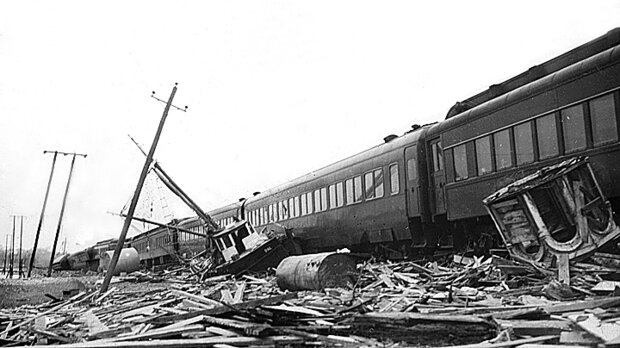
The Bostonian train encountered fishing boats and a house that had been deposited on its tracks. Lumber from the wreckage of buildings was everywhere. Photo by A. Morgan Stewart, The Day, courtesy of Peg Van Patten.
Many of my father's photographs show the Bostonian train, which miraculously escaped entrapment as it went through five feet of water on a swaying trestle bridge between Mystic and Stonington, Connecticut. In Stonington, with all the passengers huddled in one car, the train tipped off the tracks in waist-deep water, and passengers had to leap out into the wind and water and wade to safety.
Could it Happen Again?
Hurricanes arrive in New England only about once per decade, on average, but they are still part of the region's climate. As such, people shouldn't wonder "If" the Northeast will experience another hurricane like that of 1938, but rather "When?"
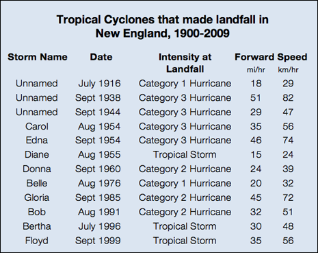
Twelve significant tropical cyclones made landfall in New England between 1900 and 2009. Storm intensity at landfall is given by The Saffir-Simpson Hurricane Wind Scale, which uses wind speeds to classify the intensity of tropical cyclones as tropical storms or hurricanes of specific categories.
The table also shows the forward motion of each storm at the time of landfall. Average forward motion of storms that have come ashore in New England is over 30 miles (50 km) per hour, well above the average speed of 10-12 miles (16-20 km) per hour observed for hurricanes in the Gulf of Mexico. Data provided by NOAA’s National Weather Service.
Twelve significant tropical cyclones made landfall in New England during the past 11 decades. Storm intensity at landfall is given by the The Saffir-Simpson Hurricane Wind Scale, which uses wind speeds to classify the intensity of tropical cyclones as tropical storms or hurricanes of specific categories.
The table also shows the forward motion of each storm at the time of landfall. Average forward motion of storms that have come ashore in New England is over 30 miles (50 km) per hour, well above the average speed of 10-12 miles (16-20 km) per hour observed for hurricanes in the Gulf of Mexico. Data provided by NOAA's National Weather Service.
A single hurricane is an extreme weather event. Predicting the timing of the next one to come ashore in New England is far beyond meteorologists' current abilities. However, patterns of hurricane frequency and intensity over time and space are connected to climate, and climate scientists are working hard to figure out if and how our changing global climate might affect hurricane patterns. Especially since 2005, when a series of strong hurricanes resulted in large numbers of casualties and billions of dollars in property damage in the United States, people have been concerned that global warming might increase the number or intensity of hurricanes that form.
Understanding how Earth's changing climate will affect patterns of hurricanes involves a range of complex factors. For example, as the temperature of the ocean's surface increases, more heat energy is available to fuel tropical systems, so the intensity of hurricanes that form might increase. However, increases in air temperatures can enhance the difference in pressure and wind speeds at different altitudes, leading to conditions that interfere with cyclone development, so the number of storms that form might decrease.
A broad community of NOAA scientists and other researchers around the world are actively working with historical records, data from lab experiments, and global climate models to understand and predict the characteristics of future hurricanes. As of early 2010, some of the most prominent tropical cyclone researchers in the United States agree that in a warmer world, hurricanes may form less frequently, yet the ones that do form may be slightly stronger than those of the past. For more information about new hurricane research, please see Satellites, Planes, and Hurricanes (available July 15, 2010)
Despite our uncertainty about when, where, and how intense future hurricanes will be, we can estimate the impacts they may have on property. Based on population density, infrastructure, and personal wealth of residents along the shores of New England, a study published in Natural Hazards Review in 2008 estimated that the price tag for a Category 3 hurricane in that region today could be as high as $70 billion. To put that amount into perspective, consider that if you spent a million dollars every day, it would take almost 200 years to spend that much money!
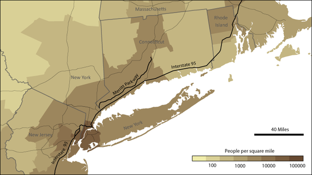
If residents of the Northeast receive an order to evacuate as a hurricane approaches, Interstate 95 and Merritt Parkway might need to be used as one-way routes, moving in either direction, to maximize the flow of traffic. Image courtesy of Hunter Allen.
If residents of the Northeast receive an order to evacuate as a hurricane approaches, Interstate 95 and Merritt Parkway might need to be used as one-way routes, moving in either direction, to maximize the flow of traffic. Image courtesy of Hunter Allen.
We can also assess the capability of existing transportation infrastructure to facilitate an emergency evacuation of the region. In July 2008, speakers at the Northeast Hurricane Mitigation Leadership Forum expressed concern over the lack of sufficient roads to evacuate the dense population centers in the region. The Interstate 95 transportation corridor serves as a major traffic artery through the Northeast. If this highway remains passable, thousands of cars per hour will be able to use it for evacuation. If that route is blocked or damaged though, gridlock could occur, and the few routes left available could be overwhelmed.
Could New England Be Surprised Again?
The potential for the Northeast to experience another "Long Island Express" is still very real. Results from NOAA's 20th Century Reanalysis Project revealed the combination of low pressure over eastern North America and high pressure over the western North Atlantic Ocean that put the 1938 hurricane on the fast track to the north. Similar pressure patterns still occur today, so New England remains vulnerable to hurricanes that can close in on the region at speeds nearing the legal limit for cars traveling on a highway.
Despite the risk, the potential for even fast-moving storms to arrive in New England without warning has diminished appreciably since 1938. An array of instruments around the world and continuous global coverage by satellites ensure that experts at NOAA's National Hurricane Center are aware of weather systems that might evolve into tropical cyclones. If a nascent storm develops the characteristics of a tropical cyclone, forecasters use a range of detailed observations to monitor its status and predict its likely path.
If a tropical cyclone develops to the point that experts judge that it may endanger lives and property, the National Hurricane Center can send Air Force and NOAA planes to fly over or through the storm to drop instrument packages into the swirling masses of clouds. Data from the instruments help the scientists understand the storm's internal characteristics and potential for further strengthening.
NOAA's high altitude jet, the Gulfstream IV, is equipped to drop small instrument packages on parachutes into storms. As the packages descend, they serve as miniature weather stations, continually measuring temperature, pressure, and humidity and sending the data back to the plane. The instruments also gather data that indicate horizontal and vertical wind speeds within the storm. Photo courtesy of NOAA.

NOAA’s high altitude jet, the Gulfstream IV, is equipped to drop small instrument packages on parachutes into storms. As the packages descend, they serve as miniature weather stations, continually measuring temperature, pressure, and humidity. Instruments on the plane receive and record these data. The instruments also gather data that indicate horizontal and vertical wind speeds within the storm. Photo courtesy of NOAA.
Global-scale numerical weather models and forecast tools, constantly updated with real-time data to characterize the current state of the atmosphere, help forecasters predict the track that hurricanes will follow. These tools have improved the accuracy of forecasts tremendously, cutting errors in storm track forecasts in half since 1995.
Beginning with the 2010 hurricane season, the National Hurricane Center will announce a watch for specified coastal areas 48 hours in advance of the time that hurricane conditions are considered possible within that area. If hurricane conditions are expected for a specified coastal area, a warning of those conditions will be issued at least 36 hours before they arrive.
With today's forecast capabilities and communications available through the Internet, television, cell phones, and radio, it seems inconceivable that residents of New England could be surprised again by a land-falling hurricane. But as recent attempts to evacuate huge cities have shown, receiving ample warning in advance of an approaching hurricane is only part of the solution. To increase chances for survival, residents also need to plan ahead and know how to access and use timely information about the best options and pathways for getting out of harm's way.
Each year, as hurricane season approaches, New Englanders who know about the Great Hurricane of 1938 still brace for the possibility that a similar storm will arrive. As hurricane seasons end, scientists compile data on all the new storms, and consider them within the context of the historical record. They look for the continuation of current trends, or a pattern that suggests a new trend has begun. Through the study of past hurricanes and the complex climate system within which they form, scientists continue striving to increase the accuracy and lead-time of their predictions. Their ultimate goal is to provide enough warning so people have the opportunity to protect themselves and their property the next time another "Big One" comes around.
Do you have comments to offer on this or another ClimateWatch article? Let us know what you think.
Peg Van Patten is Communications Director for Connecticut Sea Grant and editor of Wrack Lines, a biannual publication on coastal and marine topics with an emphasis on Long Island Sound and New England.
Further Exploration
NOAA's Historical Hurricane Tracks Viewer
Butcher, Brandon, The Great New England Hurricane of 1938, CBS 3 Springfield, Massachusetts. Accessed January 3, 2010.
References
A Centennial Review of Major Land Falling Tropical Cyclones in Southern New England, National Weather Service Forecast Office, Boston, Massachusetts. Accessed January 2, 2010.
Blake, Eric S., Rappaport, E., and Landsea, C. The Deadliest, Costliest, and Most Intense United States Tropical Cyclones from 1851 to 2006 National Weather Service, National Hurricane Center Miami, Florida, April 2007. Accessed January 2, 2010.
Connecticut Department of Environmental Protection, Long Island Sound Program. Coastal Hazards in Connecticut: The State of Knowledge and Management in 2009. 64 pp. Accessed January 5, 2010.
Human, Katy, DeLuisi, B., and Joy, L. Reconstructing History to Understand the Future. ClimateWatch Magazine. Accessed March 2, 2010.
Knutson, Thomas R., McBride, J.L., Chan, J., Emanuel, K., Holland, G., Landsea, C., Held, I., Kossin, J.P., Srivastava, A.K., and Sugi, M., 2010 Tropical Cyclones and Climate Change. Nature Geoscience published online 21 February 2010, doi:10.1038/ngeo779
National Weather Service, National Hurricane Center, Issuance Criteria Changes for Tropical Cyclone Watches/Warnings. Accessed June 5, 2010.
Northeast Hurricane Mitigation Leadership Forum, July 10-11, 2008.
Pielke, Roger A. Jr., Gratz, J., Landsea, C., Collins, D., Saunders, M.A., and Musulin, R., 2008. Normalized Hurricane Damage in the United States: 1900–2005. Natural Hazards Review 9:1, 29-42. DOI: 10.1061/_ASCE_1527-6988_2008_9:1_29. Accessed January 5, 2010.
![]()