A few days of unusually cold weather in the U.S. and Canada aren't a sign that a century-or-more trend of rising global surface temperatures has reversed itself. In fact, the cold wasn't even all that widespread for the Northern Hemisphere. For a visual reality check, all you need to do is look up- and downstream of the contiguous United States a few hundred miles.
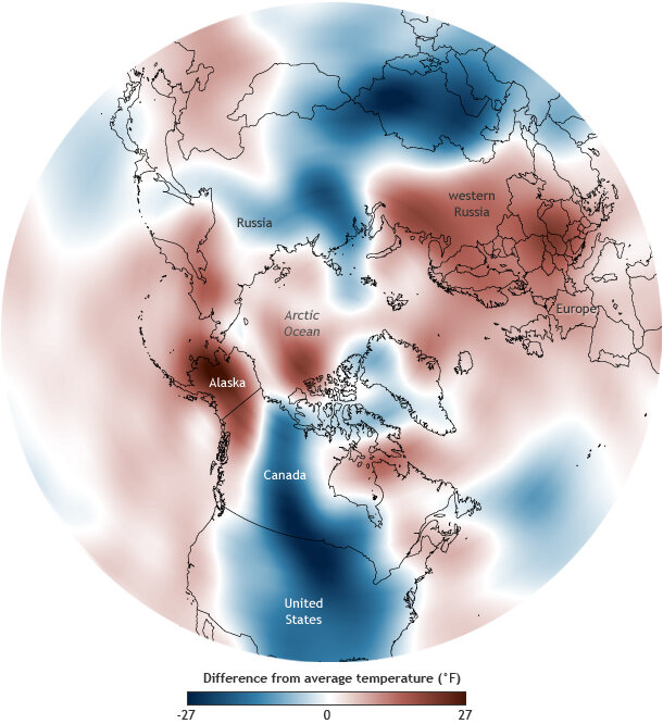
Air temperatures (1000mb) for January 5-7, 2014, compared to the 1981-2010 average. Map by NOAA Climate.gov, based on NCEP Reanalysis data provided by NOAA ESRL Physical Sciences Division.
This map shows differences from average air temperature across the Northern Hemisphere for January 5-7, 2014, based on NCEP Reanalysis data provided by NOAA ESRL’s Physical Sciences Division. Temperatures far below average are dark blue; temperatures far above average are red.
Clearly, while Americans in the Lower 48 were shivering, Alaskans were experiencing unusually balmy winter temperatures. Across the Atlantic, temperatures were warmer than average in Scandinavia, Europe, and western Russia.
These alternating temperature extremes encircling the globe are not a coincidence. These locations are connected by undulations of the jet stream, which developed deep kinks after the high-altitude Arctic circulation known as the “polar vortex” wobbled a bit in early January. Check back next week for a follow-up post on how NOAA climate scientists monitor the influence of the polar vortex through the Arctic Oscillation Index.