ENSO Blog
El Niño weakened substantially over the past month, and we think a transition to neutral conditions is imminent. There’s a 69% chance that La Niña will develop by July–September (and nearly 50-50 odds by June-August). Let’s kick off the ENSO Blog’s tin anniversary with our 121st ENSO outlook update!
Attention!
First things first: our beloved editor, Rebecca Lindsey, has trained us all very well, including being sure to acquaint our newer readers with the fundamentals of the El Niño/Southern Oscillation climate pattern, or ENSO. ENSO has two opposite phases, La Niña and El Niño, which change the ocean and atmospheric circulation in the tropics. Those changes start in the Pacific Ocean a…
Read article
Editor’s Note: Clara Deser and Stephen Yeager presented this work at a seminar (video here) in early March 2024, permitted us to share their research, and reviewed this article. They are preparing a manuscript, which is tentatively titled “Predicting the 2023/2024 El Nino and its climate impacts over North America” which will include additional technical details.
Climate scientists are basically cats. Climate forecasts, especially those generated from complex computer models, are their balls of yarn – bundles that hide an entangled mess of complex interactions that lie beneath the surface. We all know what happens when a cat sees a messy, tangled knot of string. They stalk it, pounce, and…
Read article
The El Niño of 2023–24 is weakening. Forecasters estimate an 85% chance that El Niño will end and the tropical Pacific will transition to neutral conditions by the April–June period. There’s a 60% chance that La Niña will develop by June–August. Overall, the forecast this month is very similar to last month, and we continue to expect La Niña for the Northern Hemisphere fall and early winter (around 85% chance).
La Niña and El Niño are opposite phases of the El Niño-Southern Oscillation climate pattern. “ENSO” for short. Just like El Niño, La Niña changes the ocean and atmospheric circulation in the tropics. Those changes start in the Pacific Ocean and then ripple around the world in predi…
Read article
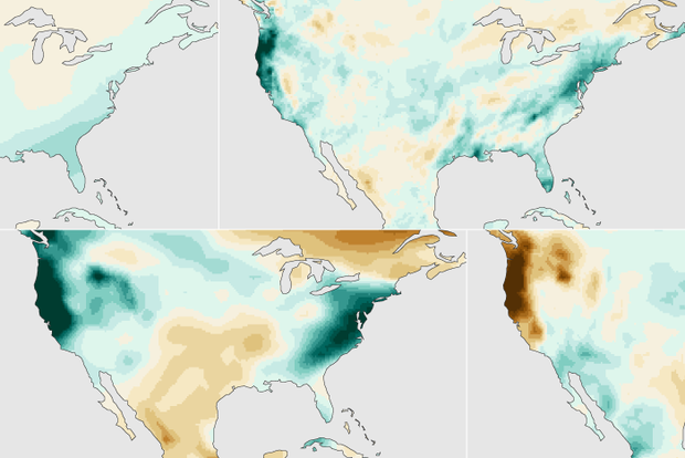
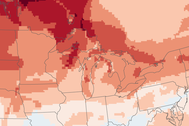
Last November, I wrote about how a strong El Niño might shape precipitation over the U.S. this winter (December – February). So, what happened? With crocuses now starting to bloom and the chirps of spring peepers in full chorus, we’re ready to investigate!
An El Niño-ish big picture
First, let’s acknowledge that a strong El Niño occurred this winter, as NOAA had been forecasting since issuing an El Niño Watch in April 2023. (If we couldn’t check that box, this would be a very short post!) We unofficially consider El Niño to be “strong” when the Oceanic Niño Index (ONI) exceeds 1.5 °C (2.7 °F), and the ONI value for this past December – February w…
Read article
El Niño—the warm phase of ENSO, which is short for El Niño-Southern Oscillation—is still hanging on in the tropical Pacific, but signs are pointing to a quick transition to neutral conditions by the April–June period. There’s a 62% chance of La Niña getting the golden ticket by June–August. Stay tuned, because La Niña affects global climate patterns, including the Atlantic hurricane season and North American winter.
Red carpet
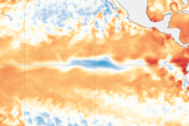
The sea surface temperature in the Niño-3.4 region of the tropical Pacific (our primary ENSO-monitoring region) was 1.6 °C (2.9 °F) above the long-term average (long-term = 1991–2020) in February, according to our most reliable dataset, ERSSTv5. This is still com…
Read article